Dissolve Boundaries
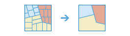
Areas that overlap or share a common boundary are merged together to form a single area.
You can control which boundaries are merged by specifying a field. For example, if you have a layer of counties, and each county has a State_Name attribute, you can dissolve boundaries using the State_Name attribute. Adjacent counties will be merged together if they have the same value for State_Name. The end result is a layer of state boundaries.
Choose area layer whose boundaries will be dissolved
The layer containing area features that will be dissolved.
בנוסף לבחירת שכבה מהמפה שלך, באפשרותך לבחור באפשרות בחר שכבת ניתוח בתחתית הרשימה הנפתחת. אפשרות זו פותחת גלריה שבה באפשרותך לעיין ולבחור ערכות נתונים ממקורות שונים לצורך שימוש בניתוח.
Choose dissolve method
You can choose one of two methods for merging area features:
- Areas that overlap or are adjacent—Two or more areas whose boundaries overlap each other will be merged into one area. In addition, areas that are adjacent (that is, they share a common boundary) will be merged into one area.
- Areas with the same field value—Areas that overlap or share a common boundary will be merged into one area if they have the same field value.
For example, if you have a layer of counties, and each county has a State_Name field, you can dissolve boundaries using the State_Name field. Adjacent counties will be merged together if they have the same value for State_Name. The end result is a layer of state boundaries.
If Use current map extent is checked, only the features in the input layer that are visible within the current map extent will be dissolved. If unchecked, all features in the input layer will be dissolved, even if they are outside the current map extent.
Create Multipart Features
In ArcGIS, a digital representation of a place or thing that has more than one part but is defined as one feature because it references one set of attributes. In a layer of states, for example, the state of Hawaii could be considered a multipart feature because its separate geometric parts are classified as a single state. This boolean parameter offers two options:
- True (checked): the output service can contain multipart features.
- False (unchecked): the output service will only contain single-part features, and individual features will be created for each part.
Add statistic
When areas are merged, you can summarize their attributes. For example, if you are dissolving the boundary between counties based on State_Name, and each county has a Population field, you could calculate the sum of Population for the state.
Available statistics types are:
- Sum—Adds the total value for the specified field
- Average—Calculates the average for the specified field
- Minimum—Finds the smallest value for all records of the specified field
- Maximum—Finds the largest value for all records of the specified field
- Std. Deviation—Finds the standard deviation on values in the specified field
Result layer name
השם של השכבה שתיווצר ב התוכן שלי ותתווסף למפה. שם ברירת המחדל מבוסס על שם הכלי ושם שכבת הקלט. אם שם השכבה כבר קיים, תתבקש לספק שם אחר.
בעזרת התפריט הנפתח שמור תוצאה ב, באפשרותך לציין את שם התיקייה ב תוכן שלי שבה התוצאה תישמר.