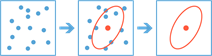
Summarize Center and Dispersion
This tool finds central features and directional distributions. It can be used to answer questions such as:
- Where is the center?
- Which feature is the most accessible from all other features?
- How dispersed, compact, or integrated are the features?
- Are there directional trends?
If Use current map extent is checked, only those features in the input layer and the layer to be summarized that are visible within the current map extent will be analyzed. If unchecked, all features in both the input layer and the layer to be summarized will be analyzed, even if they are outside the current map extent.
Choose a layer to be described
The point, line, or area layer that will be used to find central features and directional distributions.
In addition to choosing a layer from your map, you can choose Choose Analysis Layer at the bottom of the drop-down list to browse to your contents for a big data file share dataset or feature layer. You may optionally apply a filter on your input layer or apply a selection on hosted layers added to your map. Filters and selections are only applied for analysis.
Summary types
The method of summarizing center and dispersion.
- Central feature - Identifies the most centrally located feature in a dataset.
- Mean center - Identifies the geographic center (or the center of concentration) for a set of features.
- Median center - Identifies the location that minimizes overall Euclidean distance to the features in a dataset. This is calculated as the geometric median.
- Ellipse - Creates standard deviational ellipses to summarize the spatial characteristics of geographic features: central tendency, dispersion, and directional trends. The ellipses can be sized as 1, 2, or 3 standard deviations.
Weight by
The field used to weight locations according to their relative importance.
Group by
The field used to group features for separate computations of central features or dispersion.
Choose datastore
GeoAnalytics results are stored to an data store and exposed as a feature layer in Portal for ArcGIS. In most cases, results should be stored to the spatiotemporal data store and this is the default. In some cases, saving results to the relational data store is a good option. The following are reasons why you may want to store results to the relational data store:
- You can use results in portal-to-portal collaboration.
- You can enable sync capabilities with your results.
You should not use the relational data store if you expect your GeoAnalytics results to increase and need to take advantage of the spatiotemporal big data store's capabilities to handle large amounts of data.
Result layer name
The name of the layer that will be created. If you are writing to an ArcGIS Data Store, your results will be saved in My Content and added to the map. If you are writing to a big data file share, your results will be stored in the big data file share and added to its manifest. It will not be added to the map. The default name is based on the tool name and the input layer name. If the layer already exists, the tool will fail.
When writing to ArcGIS Data Store (relational or spatiotemporal big data store) using the Save result in drop-down box, you can specify the name of a folder in My Content where the result will be saved.